Two types of navigation
were used, celestial navigation and a process called dead reckoning.
 Celestial navigation is done with the use
of a sextant, or octant, the horizon (if they could see it)
or an artificial horizon (when they couldn’t) and a very
good watch called a chronometer.
Celestial navigation is done with the use
of a sextant, or octant, the horizon (if they could see it)
or an artificial horizon (when they couldn’t) and a very
good watch called a chronometer.
Lewis or Clark would then
use these instruments to measure the angle of the sun, or
other celestial body from the horizon to find the latitude.
Latitude is the distance north or south of the equator. To
find the longitude or the lines of distance from east to
west can be found by comparing local time with that of the
Prime Meridian at Greenwich, England. Not an easy chore with
a clock (chronometer) that has to be wound daily and error
factor that needed to be calculated and reset, and
observations of the sun at local noon.
Keep in mind this is
a brief explanation of what is needed to mark latitude and
longitude. There are many other calculations involved to
zero in on the locations and adjust equipment.
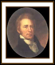
The other type of navigation was dead reckoning, and William
Clark became a master. Dead
Reckoning is the process of estimating your position by
advancing a known position using course, speed, time and
distance to be traveled.
In other words figuring out where you
will be at a certain time if you hold the speed, time and course
you plan to travel.
If you know your rate of speed and how long you
have traveled, you can figure out how far you have come. S
(speed) times T (time) divided by 60 (minutes) equals D
(distance). Your formula is:
Distance = Speed times Time divided by 60.
Now give it a try. If you are driving 60 miles
per hour for one hour, how far have you driven?
This is a very simple form of dead reckoning.
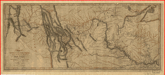
Clark had to first plot a course, calculate speed, and adjust
for other variations. Which was an incredible feat when you
figure that they were only about 40 miles off in over 8000 miles
of travel.
US Library of Congress